Ruelle Sur Touvre

GET A QUICK, FREE QUOTE

    Excellent Trustpilot

    Rated 'Excellent'
    on Trustpilot

    ECMT International Removals Permit

    ECMT International
    Removals Permit

    British Association of Removers

    British Association
    of Removers

    Eco Friendly Removals

    Eco Friendly
    Removals

    Our Removals Service Includes…

    For removals to and from Ruelle Sur Touvre.

    What our customers say...

    Ruelle Sur Touvre

    Where a historic foundry with a proud military history still operates

    Ruelle is a town three miles from Angoulême, towards Limoges. Nearly 8,000 people live here, surrounded by the hills and valleys in the beautiful Charente Department.

    Limoges railway line crosses the town and Ruelle has a station with five services a day.

    Ruelle has many neighbourhoods. The old town of Ruelle was made up of four old villages, the town, Maine-Gagnaud, the Pont and the Quartier neuf.

    Important areas include Villement to the west, Seguins and Bel-Air to the south on the left bank of the Touvre, Fourville, Vesingade, Puyguillem (the Cité scolaire ), the Grands Champs, Vaugeline and Fissac on the right bank, and to the east of the town, the Riffauds.

    Vaugeline was the testing ground for cannons forged at the foundry, and a small railway line connected it to the factory.

    The town is flanked by the hills of Bel-Air, on the bank of the Touvre, and by the hillside of Villement, which separates the valley of the Touvre from that of the Viville stream.

    Les Riffauds is an old hamlet which grew considerably bigger in the 1970s. It is high above sea level and offers a stunning view of the hilly terrain, Ruelle and the Angoulême area.

    Fourvilles, Puyguillem, Great Fields and Vaugeline also overlook the Touvre, separated by valleys.

    La Touvre crosses the town and supplies the foundry with a constant flow of water.

    The foundry has a proud history which dates back to 1753, when the Marquis de Montalembert built a forge with two blast furnaces to make cannons for the Navy. It became became the Royal Foundry of the Navy in 1776.

    The foundry produced the 400mm guns which crushed the superstructures of Fort Douaumont, which the Germans had captured during the First World War.

    It is still operating today and employs hundreds of people.

    There were once mills here – the mill Terrière was a paper mill in the 17th century. There was also an oil mill and a flour mill that closed at the end of the 20th century.

    The mill Villement was a wheat mill, which was converted into a large forge in 1828, then became the Alamigeon paper mill which employed around 100 people in 1909 and around 40 today.

    Other major employers are dotted around the town.

    Sodatec, an installer in electronic transactions and communication technologies, employs 110 people.

    The Amkey consulting company employs 75 people.

    Ruelle has a shopping area and popular markets on Thursdays and Sundays. There is also an Intermarché on the outskirts of the town.

    There’s plenty of sporting facilities here, with three gyms and three stadia. And there’s a cultural centre and a media library, hosting many exhibitions and events.

    Alley also has a theatre with a capacity of 650 people.

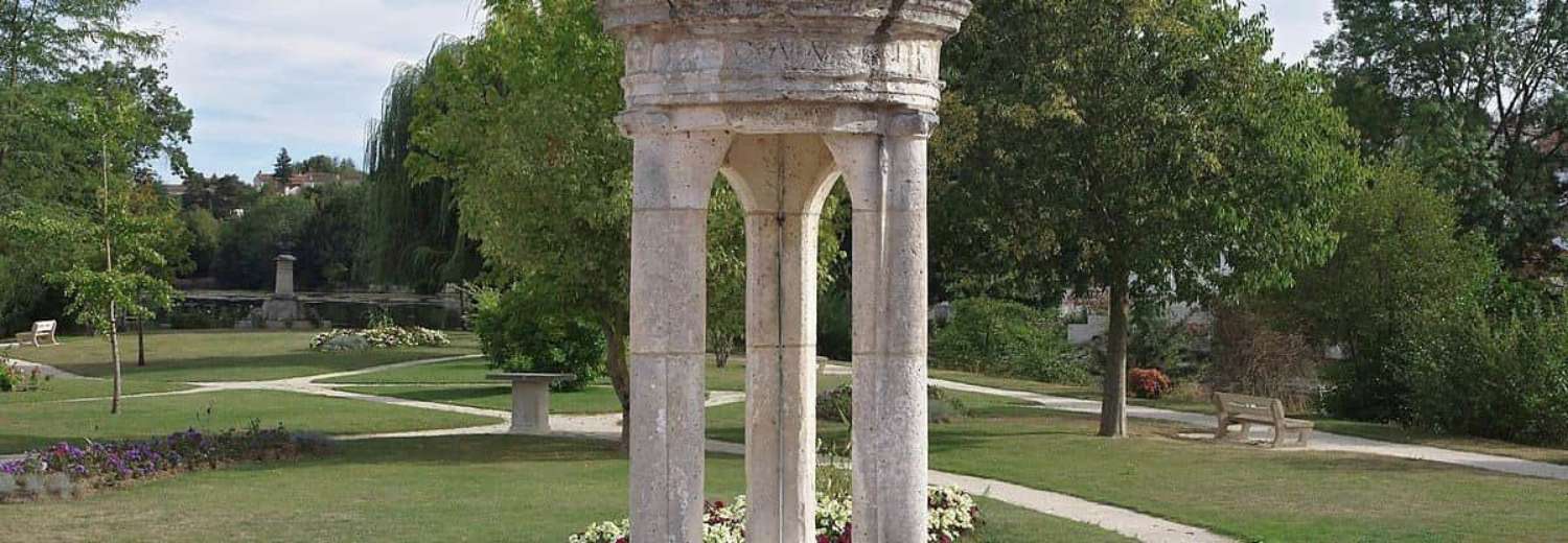
    Many historic structures are still to be found here, with the 16th century fountain François, the 17th century home of Fissac dating and the small parish church of Saint-Médard de Ruelle.

    Ruelle Sur Touvre Village History

    In the Middle Ages, Ruelle bore the name of a fiefdom under the seigneury of La Tranchade (Birot family).

    Fissac belonged to the Tison d’Argence and the Duke of Montpensier retired there in 1568 after failing in his attempt to take Angoulême back from the Protestants. He was joined there by the future King Henri III.

    The home of the Maine-Gagnaud, on the site of the current foundry, hosted Francis Ist on one of his visits to the sources of Touvre. He built a Renaissance fountain that still bears his name and is on display in front of the foundry.

    In 1750 the Marquis de Montalembert bought a small paper mill on the Touvre, in Maine-Gagnaud on the site of the current foundry, and in 1782 made it one of the most beautiful forges in the kingdom. Iron ore was transported from Périgord and from the borders of Angoumois and the wood came from the nearby forests.

    The road to Limoges descending from Les Favrauds to the foundry (the D 941) was built in 1778-1779. The road was later extended to Bel-Air and L’Isle-d’Espagnac, and the bridge dates from 1846.

    In 1880 the foundry was augmented by the personnel of the foundry of Nevers, and the population of Ruelle expanded rapidly.

    Removals service

    Whatever your removal needs we can handle it – we’ve been moving people for nearly 50 years and know how to deal with any situation.

    We are fully insured and have a great team to help reduce the stress of moving.

    You can call us on 0800 917 1015 or email enquiries@armishaws.com for a quote.

    Allow us to move you to or from anywhere in the UK or Europe. Our staff have been well trained in all aspects of moving homes and businesses.

    Armishaws has held the BSEN 12522 certificate since 1999.

    Why Choose Armishaws

    • Any distance
    • Any amount
    • Global shipping
    • Removals to France, Spain and Portugal
    • Storage facilities
    • Export wrapping and packing service,
    • Family-owned since 1973
    • Free survey and a same-day quote

    Armishaws has depots all over the country, having taken over many other removals firms. While they have all kept their own branding, you can tell it’s an Armishaws company by the stellar service!

    For Free Advice and a Quotation call 0800 917 1015

    Why move to Ruelle Sur Touvre?

    There are, according to other expats, lovely people here, with lovely countryside, easy access to the airport at Limoges and an ‘excellent’ medical service. The weather is sunny – much sunnier than the UK – without being harsh.

    Properties in Ruelle Sur Touvre

    Properties here are incredibly reasonable, with flats around the £50k mark and townhouses from £100k. Check www.rightmove.co.uk for homes available.

    Schools near Ruelle Sur Touvre

    The Cité scolaire is in Puyguillen and there is a secondary school here, plus a high school. There are two elementary schools, three nursery schools and a popular university.

    We cover the whole of Ruelle Sur Touvre and the surrounding area

    Brie

    Despite its name, Brie in the Charente Department is nothing to do with cheese.

    According to Dauzat, the origin of the name Brie dates back to the Gallic Briga meaning ‘height’.– slightly confusing as Brie is not on a height.

    Angoulême-Cognac international airport, also called Angoulême-Brie-Champniers airport, is on the edge of the town, and on the other side lies a stunning chasm called La Grande Fosse.

    The Brie people – of whom there are just over 4,000 – are called the Briauds and the Briaudes.

    Brie is about seven miles from Angoulême and two miles from Champniers. It is crossed by the D 12 road from Angoulême to Chasseneuil.

    The N 141 from Saintes to Limoges via Angoulême and a link on the Center-Europe Atlantique road limits the town to the south-east.

    Brie has many important hamlets, including the Rassats, the Frauds, the Frotards, the Prévôterie, the Simarde (straddling Champniers), the Jauvigère and the Temple.

    The soil of the town consists of limestone dating from the Upper Jurassic and is part of the karst of La Rochefoucauld.

    The town occupies a plateau at an altitude of 130m, with a north-south ridge between Frauds and Jauvigère over the Braconne forest. The highest point is 167 metres near the water tower. Many valleys run through this plateau including the Great Pit.

    The Braconne forest to the east hosts the military camp of the 515th regiment.

    In the 19th and 20th centuries, Brie was nicknamed Brie la Rochefoucauld to distinguish it from other cities of the same name in Charente.

    The association with the military goes back years.

    In the 19th century, the war office established the shooting range in the Braconne and at the start of the 20th century  regiments of the 12th army corps were stationed here.

    The surrounding agriculture is mainly cereals and wine – the town is part of the Cognac region.

    The parish church of Saint-Médard dates from the 12th and 13th centuries. There are two fireplaces here, one of which is decorated with scallops.  The church was restored in the 2000s.

    In the village of Frauds, the neo-Gothic style chapel Chapel of Notre-Dame de La Braconne  was built in 1905. Two stained glass windows represent Saint Barbara, patron saint of artillerymen, and Saint Hubert, patron saint of hunters. It was sold in 2005 and sometimes hosts exhibitions.

    Garat

    Garat, which lies six miles from Angoulême and three miles from Soyaux. has grown enormously since the 1980s.

    Its 2,000 or so inhabitants are called the Garatois and the Garatoises.

    It is accessed from Angoulême by the D 939 to Périgueux, half a mile from the crossroads with the road to Nontron.

    The town has many hamlets, the largest of which is Sainte-CatherineLe Boisseau and Bragette are south of the town.

    There is also Villars, la Brousse, les Champs, Peu Sec, le Grand Arsac, les Bournies, chez Méry, le Grand Lac, Maison Neuve, Denat, les Grandes Tuileries and le Plantier.

    There are two castles here – La Tranchade and Chément.

    There is a cuesta here – a gentle slope on one side and a sharp slope on the other – the hamlets of Sainte-Catherine, Bellevue and Bragette are on the gentle slope. The highest point of the town, at an altitude of 169 m, is in Maison Neuve on the road to Périgueux, between Sainte-Catherine and Soyaux. The lowest point, at 52 metres, is on the Ladder at the exit of the town, near Varennes.

    The Ladder stream, which is the main tributary of the Touvre, crosses the town and there are small tributaries including the Rochejoubert stream.

    The Anguienne, a tributary of the Charente, borders the town between the Boisseau and the Got mill, passing at the foot of the Château de la Tranchade.

    About half of the area is wooded, especially higher up, where the national forest of Bois Blanc sits to the east.

    The soil is more fertile around the valley of the Scale than on the heights of Sainte-Catherine, in particular at Maison Neuve where the clay soil has produced chestnut trees, maritime pines, oaks and gorse.

    Before the Revolution, Garat was made up of two parishes, Garat and Ladoux. Ladoux was on the high plateau along the Périgueux road.

    Before the 17th century, the area belonged to the abbey of Saint-Cybard, but the monks yielded to Gérard Ramnulphe and in the 14th century the Tranchade went to the lords of Pressac, who built the castle keep. In 1573, the estate passed to the Nesmond family.

    Garat has a nursery school and an elementary school.

    Its church, St Peter in Chains, dates from the end of the 12th century and the 14th century, listed as a historical monument in 1926.

    The Tranchade castle was built at the end of the 14th century and rebuilt in the 17th century. It dominates the Anguienne Valley and features a moat cut into the rock. It was classified as a historical monument in 1970.

    The Hermitage of Bragette is a picturesque residence where Doctor Bouillaud was born in 1796.

    The GR 4 hiking trail from Royan to Grasse and the GR 36 from Manche to the Pyrenees cross the town.

    La Rochefoucauld-en-Angoumois

    La Rochefoucauld-en-Angoumois is a new commune created at the beginning of 2019.

    The name of the new town comes from the town of La Rochefoucauld, as well as from its position in the province of Angoumois.

    The town is in the Occitan part of the Charente, whose dialect is Limousin. The forest of Braconne marks the western limit with the langue d’oïl. The town is called La Ròcha Focaud-d’Engolmés in Occitan.

    The town was created after the merger between La Rochefoucauld and Saint-Projet-Saint-Constant.

    There are already several primary and secondary schools here.

    Significant employers include a vocational training establishment and a professional baccalaureate service.

    Bunzac

    Bunzac is nine miles east of Angoulême and three from La Rochefoucauld along the Bandiat valley. The village is on the plateau between the valley and that of the Tardoire which passes to Rancogne to the east.

    The town is away from the major roads, but the Angoulême-Limoges railway crosses the town, via the Braconne and Montgoumard. A branch serves the former American camp of Braconne, which today is called ZE de la Braconne (economic zone).

    Montgoumard is a hamlet to the west of the town, which has other smaller hamlets: les Fouilloux, la Petite Garde, la Grande Garde, chez Roby, Anthieu, Pierre Levée, Puy Cocu and the Château des Deffends. There are also three farms.

    The town is on a plateau with an average altitude of 120m. It is quite wooded, with mixed farming (sunflowers, corn…) There are also many walnut trees and oil is made at the Trotte-Renard mill, on the Bandiat.

    The town includes part of the Braconne national forest – the Bois-Long forest.

    Some historic remains have been found in the town – including slag from old forges, tegulae, and terracotta tiles.

    The parish church of Saint-Symphorien was built in the 12th century.

    Other significant buildings include the castle of Deffends, the noble house of Hautefaye, the Montgoumard house, the home of Anthieu and the mill of Trotte-Renard.

    Pranzac

    Pranzac is nine miles from Angoulême and seven from Montbron in the Bandiat valley.

    It is five miles from La Rochefoucauld.

    The Angoulême-Limoges line crosses the west of the town and the old Quéroy-Pranzac station is Pranzac. However the closest stations are now Ruelle station, six miles away, or La Rochefoucauld.

    Among the main areas are Marsac, Glane, Gros Terme, Flamenac, Chez Maillet, A Monot and the Hermitage.

    The town occupies a low plateau with an average altitude of 115 metres, cut by the shallow valley of Bandia. The highest point is 132 metres in Flamenac.

    The town is in the Bandiat basin, a tributary of the Tardoire. The Bandiat is sometimes dry in summer. The Bandiat canal passes through the town.

    The Bandiat valley is full of meadows but outside this the town is very wooded.

    The town is in the Occitan part of the Charente and the dialect is Limousin.

    There have been settlements here for hundreds of years – a 5th century sarcophagus was once discovered here.

    The church dates from the Romanesque period and the 18th century lantern of the dead overlooks the old cemetery.

    During the Middle Ages, Pranzac was on a route frequented by pilgrims on their way to the sanctuary of Saint-Jacques-de-Compostelle and to the relics of Saint Eutrope in Saintes.

    The 15th century castle Pranzac was owned by Alexandre Redon, Marquis de Pranzac in 1666. In 1682, his daughter, Marie-Barbe-Françoise Dreux Redon de Salens, married François de Pérusse, count of Cars and of Saint-Bonnet. He also owned the home of Chez Monot, which was the chateau’s farm. During the Revolution, the Count of Cars emigrated and his property was sold.

    One of the main features of Pranzac is its lantern of the dead, which dominates the old cemetery – today transformed into a public square.  It is a hollowed-out column nearly seven metres high, pierced at the top with small windows giving passage to the light.

    Saint-Cybard Church dates from the Romanesque period with a stately Renaissance chapel.

    The stately home, next to the castle and near the church, dates from the 16th century and is well preserved.

    The old banal mill near the castle was restored in 1980.

    Abbot Roux’s house. Another old home near the lantern of the dead, which features a turret was once lived in by the revolutionary abbot Jacques Roux, who led Louis XVI to the scaffold.

    The old railway line from Angoulême to Nontron has been converted into a cycle path and long-distance hiking trail the GR 4 crosses the centre of the town.

    Thinking of moving house? Get in touch to request a quote

    Get a Quick Quote

      Yes